
The Southern Arizona Dark Sky Network (DSN) is an environmental monitoring system that addresses one of the most overlooked yet pervasive threats to our ecosystem: light pollution. Comprising 35 advanced sensors deployed across Southern Arizona, the DSN continuously measures the night sky brightness to protect a $550 million astronomical economy, safeguard critical wildlife habitats in the biodiverse Sonoran Desert, and address significant human health impacts from artificial light at night.
Why This Matters: Light pollution disrupts nocturnal pollinators essential to desert ecosystems, disorients migrating birds, suppresses human melatonin production leading to sleep disorders and increased disease risk, and threatens the "world capital of astronomy's" pristine observing conditions. Unlike other forms of pollution requiring decades of remediation, light pollution is uniquely reversible—turn off a light, and the pollution disappears instantly.
What We're Doing: Using proven SQM (Sky Quality Meter) and TESS sensor technologies, the DSN serves as an early warning system, detecting light pollution increases before they become critical, guiding evidence-based lighting policy decisions, and documenting the effectiveness of conservation efforts. Data from the network is publicly accessible at darkskysoaz.org, empowering communities to see real-time changes in their night skies and understand the direct connection between lighting choices and environmental health.
Current Status: Sensor deployment began in spring 2025, with full network operation expected by mid-2026. Early results are already available for visualization and analysis, establishing crucial baseline measurements that will guide future conservation decisions and demonstrate that protecting darkness protects life itself.
The Southern Arizona Dark Sky Network (DSN) is a system of 35 sensors spread across Southern Arizona that measure the brightness of the night sky. They record measurements every 5 minutes. Think of them as "weather stations" for the night sky – they continuously track its brightness and how it changes over time.
Figure: Distribution of Dark Sky Network monitoring sites across Southern Arizona. Orange markers indicate existing operational stations; red markers show proposed expansion sites.
The Dark Sky Network's monitoring stations are strategically distributed across the greater Tucson metropolitan area and extending into surrounding communities to provide comprehensive coverage of sky quality conditions. The network currently includes 20 existing operational sites (shown in orange) with 24 proposed expansion locations (shown in red), spanning from the Colorado River region in the west to Gila National Forest in the east.
Urban Core Monitoring: The highest density of monitoring stations is concentrated in and around the City of Tucson, where light pollution is most intense. Multiple stations are positioned throughout the metropolitan area to capture variations in sky brightness across different neighborhoods, commercial districts, and proximity to major roadways. This urban monitoring is critical for assessing compliance with the Tucson/Pima County Outdoor Lighting Code and tracking the effectiveness of streetlight retrofits and other light pollution mitigation efforts.
Suburban and Growing Communities: A significant number of stations are located in suburban areas including Marana, Oro Valley, Sahuarita, and Green Valley. These locations are particularly important as they represent areas of rapid growth where lighting policies have the greatest potential impact on future sky quality. The suburban stations also serve as buffers between the urban core and darker rural areas, helping to document light pollution propagation patterns.
Dark Sky Communities: Several monitoring stations are positioned in or near communities that have achieved or are pursuing International Dark Sky Community certification, including Tubac and Bisbee. These stations document the exceptional sky quality that these communities have worked to preserve and provide ongoing verification of their dark sky protection efforts.
Rural and Remote Sites: The network extends into rural areas of Pima, Pinal, Santa Cruz, and Cochise counties, with stations in remote locations that provide baseline measurements of near-natural sky conditions. These rural sites are essential for understanding the full extent of sky glow from urban areas and for documenting the quality of truly dark skies that Southern Arizona is known for. Remote stations near the San Carlos Reservation, Gila National Forest, and in southeastern Arizona capture conditions far from major population centers.
Scientific and Cultural Areas: Several sites are located near areas of particular scientific or cultural significance. Stations in proximity to Kitt Peak National Observatory, Mount Hopkins, and Mount Lemmon help monitor light pollution impacts on these world-class astronomical facilities. The network also includes monitoring near Tohono O'odham Nation lands and other indigenous areas where preservation of natural night skies holds cultural importance.
Coverage Strategy: The geographic distribution follows a hub-and-spoke pattern, with dense coverage in the Tucson metropolitan core radiating outward along major transportation corridors (I-10, I-19, State Route 86) and into surrounding valleys and mountain communities. This design allows the network to monitor light pollution gradients from urban centers to rural areas, track the impact of specific development projects, assess the effectiveness of lighting zone regulations, and provide early warning of sky quality degradation in protected areas.
Southern Arizona is home to world-famous astronomical observatories and has been called the "world capital of astronomy." The region's dark skies are worth over $550 million annually to the local economy and support thousands of jobs. But light pollution from cities can travel hundreds of miles, threatening these precious dark skies.
Unlike other forms of pollution, light pollution affects virtually every aspect of our ecosystem – yet it remains one of the least understood environmental threats:
Effects on Wildlife and Ecosystems:
The Sonoran Desert, one of the world's most biodiverse deserts, hosts numerous species whose survival depends on natural darkness:
Human Health Impacts:
Artificial light at night doesn't just harm wildlife – it directly affects human health:
The good news: Light pollution is uniquely reversible
Here's what makes light pollution different from other environmental challenges: it's the most straightforward form of pollution to control. Unlike air or water pollution, which can take decades to clean up and require complex chemical processes:
This makes light pollution one of the most solvable environmental problems we face. Every properly shielded light fixture, every unnecessary light turned off, and every community that adopts smart lighting policies creates immediate benefits for wildlife, human health, and energy conservation.
The Dark Sky Network uses two types of widely used sensors to measure night sky brightness:
Both sensor types provide complementary data, giving us a comprehensive picture of sky brightness across Southern Arizona. The combination of these technologies allows us to validate measurements and ensure the highest quality data for research and advocacy.
The network acts as an early warning system for light pollution. By continuously monitoring sky brightness across the region, it can:
This project helps Southern Arizona protect one of its most valuable natural resources – its dark night skies – while supporting astronomical research, human health, desert wildlife survival, and energy conservation. The data will be publicly available at darkskysoaz.org, allowing everyone to see how their local night sky is changing over time and understand the connection between outdoor lighting choices and environmental health.
We began deploying sensors in spring 2025, with full operation expected by mid-2026. This represents a critical moment: by establishing baseline measurements now, we can track changes, guide policy decisions, and demonstrate that protecting darkness protects life itself.
Early results from the Dark Sky Network are already available and can be visualized at: https://soazcomms.github.io/DSNweb.v04.html
The data are freely available for download to all users. For instructions on how to access and use the data, please see:
Data Usage Instructions
Here is an example visualization:
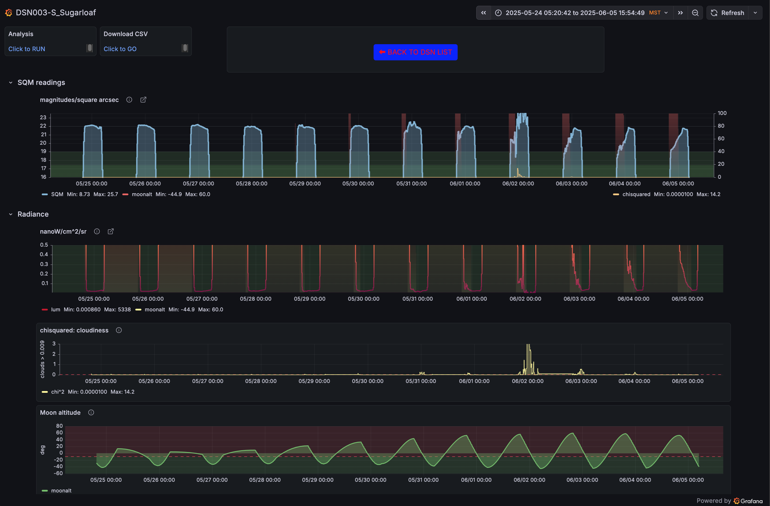
Understanding the visualization:
This dashboard shows data from a single monitoring station (DSN003-S_Sugarloaf) over approximately two weeks in late May to early June 2025. The visualization displays four key metrics:
Together, these panels tell a complete story about sky conditions: You can see the day-night cycle, identify when clouds passed through, understand the moon's influence, and detect any unusual brightness that might indicate light pollution. The consistent baseline sky brightness during moonless nights shows this location maintains excellent dark sky quality.
When we measure how bright (or dark) the night sky is, we use two different units. Think of them as two different ways to measure the same thing – like measuring distance in miles versus kilometers.
Here is an example of the difference in night sky brightness for a site with significant light pollution in Tucson and a dark sky in the Chiricahuas:
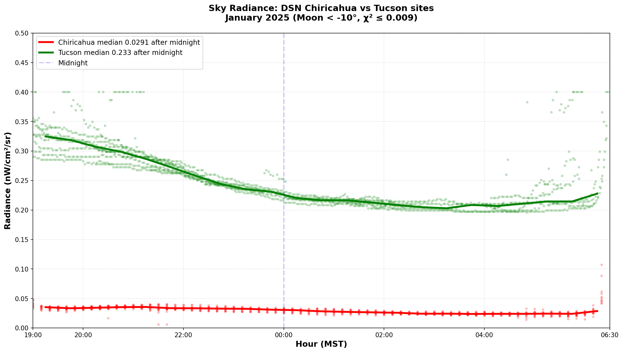
As Tucson lights are turned off through the evening, the radiance decreases and then plateaus after midnight, when the Tucson/Chiricahua ratio of radiances settles at about 8. This demonstrates how even after most lights are turned off, urban light pollution maintains a significantly brighter sky throughout the night compared to pristine dark sky locations.
Magnitudes per square arcsecond (mag/arcsec²)
This is the astronomer's way of measuring brightness. It's a bit backwards from what you might expect:
For example:
The scale is logarithmic, meaning each whole number represents about 2.5 times more or less light. So a sky at 19 is about 2.5 times brighter than a sky at 20.
Nanowatts per square centimeter per steradian (nW/cm²/sr)
This measures the actual physical brightness – the amount of light energy hitting your eye from a patch of sky. Unlike magnitudes:
This works the way you'd naturally expect: more light = bigger number.
Why two measurements?
Astronomers traditionally use magnitudes because that's how we've measured star brightness for centuries. But scientists and engineers often prefer the physical units (nW/cm²/sr) because they're easier to use in calculations and relate directly to the actual light levels.
The bottom line: Both measurements tell the same story – whether your night sky is dark enough to see the Milky Way or if light pollution is washing it out. We provide both so astronomers and scientists can each use what works best for them!
For a technical description of the visualization software and data processing, see: Technical Documentation